
Fișier:2011 Tohoku earthquake observed tsunami heights en.png
Mărimea acestei previzualizări: 656 × 600 pixeli. Alte rezoluții: 263 × 240 pixeli | 525 × 480 pixeli | 700 × 640 pixeli.
Fișier original (700 × 640 pixeli, mărime fișier: 298 KB, tip MIME: image/png)
| Acest fișier este de la Wikimedia Commons.. Descrierea de mai jos poate fi consultată la pagina de descriere a fișierului. |
| Descriere |
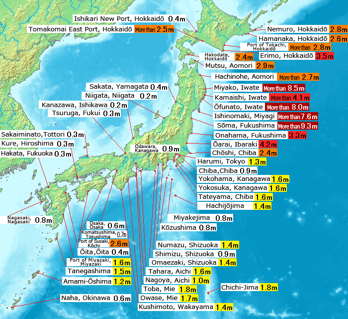
English: Map of 2011 Tohoku(Sendai) earthquake observed tsunami heights in Japan.
日本語: 東北地方太平洋沖地震で観測された、日本各地の津波の高さ(英語版)。 |
||||||
| Dată | |||||||
| Sursă |
This file was derived from: 2011 Tohoku earthquake observed tsunami heights.png |
||||||
| Autor | Original by Pekachu, translated by Eastwind41 | ||||||
| Permisiune (Reutilizarea acestui fișier) |
|
||||||
| Alte versiuni |
SVG re-designed version available |
| Această imagine a fost retușată, ceea ce înseamnă că a fost modificată pe cale digitală și este diferită de cea inițială. Modificări: Place name translating to English language(地名の英訳).
|
Istoricul fișierului
Apăsați pe Data și ora pentru a vedea versiunea fișierului trimisă la momentul respectiv.
| Data și ora | Miniatură | Dimensiuni | Utilizator | Comentariu | |
|---|---|---|---|---|---|
| actuală | 14 mai 2011 13:43 | | 700x640 (298 KB) | Eastwind41 | {{Information |Description ={{en|1=Map of 2011 Tohoku(Sendai) earthquake observed tsunami heights in Japan.}} {{ja|1=東北地方太平洋沖地震で観測された、日本各地の津波の高さ(英語版)。}} |Source ={{Derived from|2011 |
Utilizarea fișierului
Următoarea pagină folosește acest fișier:
Utilizarea globală a fișierului
Următoarele alte proiecte wiki folosesc acest fișier:
- Utilizare la en.wikipedia.org
- Utilizare la mk.wikipedia.org
- Utilizare la ms.wikipedia.org
- Utilizare la th.wikipedia.org